Difference between revisions of "Innsbruck"
Markus Dierl (talk | contribs) |
|||
| (11 intermediate revisions by 7 users not shown) | |||
| Line 1: | Line 1: | ||
| + | {{Infobox airport | ||
| + | | name = Innsbruck Kranebitten Airport | ||
| + | | nativename = | ||
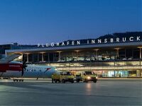
| + | | image = Innsbruck Airport.jpg | ||
| + | | image-width = 200 | ||
| + | | image2 = | ||
| + | | image2-width = | ||
| + | | IATA = INN | ||
| + | | ICAO = LOWI | ||
| + | | type = Public | ||
| + | | owner = | ||
| + | | operator = Tiroler Flughafenbetriebs GmbH | ||
| + | | city-served = | ||
| + | | location = Innsbruck | ||
| + | | hub = Tyrolean Airways | ||
| + | | elevation-f = 1906 | ||
| + | | elevation-m = 581 | ||
| + | | coordinates = | ||
| + | | latd = 47 | latm = 15 | lats = 37 | latNS = N | ||
| + | | longd= 11 | longm= 20 | longs= 38 | longEW= E | ||
| + | | latd = 47 | latm = 15 | lats = 37 | latNS = N | ||
| + | | longd= 11 | longm= 20 | longs= 38 | longEW= E | ||
| + | | coordinates_type = | ||
| + | | coordinates_region = AT | ||
| + | | coordinates_notitle = yes | ||
| + | | website = [https://www.innsbruck-airport.com/en www.innsbruck-airport] | ||
| + | | pushpin_map = Austria | ||
| + | | pushpin_label_position = Top=46 Left=71 | ||
| + | | pushpin_label = LOWI | ||
| + | | pushpin_map_alt = | ||
| + | | pushpin_mapsize = | ||
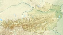
| + | | pushpin_image = Austria relief location map.jpg | ||
| + | | pushpin_map_caption = Location within Austria | ||
| + | | metric-elev = Y | ||
| + | | metric-rwy = y | ||
| + | | r1-number = 08/26 | ||
| + | | r1-length-f = 6562 | ||
| + | | r1-length-m = 2000 | ||
| + | | r1-surface = Asphalt | ||
| + | | footnotes = | ||
| + | }} | ||
| + | |||
== Innsbruck Kranebitten ([[LOWI]]) == | == Innsbruck Kranebitten ([[LOWI]]) == | ||
The airport was opened 1925 and is located on the west side of Innsbruck near the river Inn just about 3.5km away from the centre. Innsbruck became famous of his difficult west approach and was a long time one of the five most dangerous airports in the world. Since 29 February 1964, when an Bristol Brittania 312 (British Eagle Airlines) crashed into a southern mountain Glungezer (2610m), only special trained pilots are allowed to land in Innsbruck. | The airport was opened 1925 and is located on the west side of Innsbruck near the river Inn just about 3.5km away from the centre. Innsbruck became famous of his difficult west approach and was a long time one of the five most dangerous airports in the world. Since 29 February 1964, when an Bristol Brittania 312 (British Eagle Airlines) crashed into a southern mountain Glungezer (2610m), only special trained pilots are allowed to land in Innsbruck. | ||
| − | Also specialities in Innsbruck are the 2 LOC/DME approaches. The OEV locator from the east has a 5 degrees offset to the runway, compared to the OEJ locator from the west which is leading the aircraft north over the airport. | + | Also specialities in Innsbruck are the 2 LOC/DME approaches. The OEV locator from the east has a 5 degrees offset to the runway, compared to the OEJ locator from the west which is leading the aircraft north over the airport. The east instrument approach end latest at D3.5 OEV and the west instrument approach end latest at D4.4 OEJ where the visual part begins. |
| − | Innsbruck is the base of Austrian Arrows | + | Innsbruck is the base of Tyrolean Airways (100% subsidiary of Austrian Airlines - Brand Name:Austrian Arrows), Tyrolean Jet Services, Tyrol Air Ambulance and Welcome Air. Additionally Air Alps has its technical base in Innsbruck. In the year 2005 the airport handled 40.389 movements and 738.296 passengers. That’s an increase of 2.57% for movements and 1.40% for passengers compared to the year 2004. |
In winter time the traffic is increasing significantly (more than 100 movements/day), mostly on Saturdays, as a result of the charter flights from Europe and Russia to the great ski region Tyrol in the middle of the Alps in Austria. | In winter time the traffic is increasing significantly (more than 100 movements/day), mostly on Saturdays, as a result of the charter flights from Europe and Russia to the great ski region Tyrol in the middle of the Alps in Austria. | ||
| + | |||
| + | [[Category:Airports]] | ||
Latest revision as of 08:16, 21 October 2019
| Innsbruck Kranebitten Airport | |||
|---|---|---|---|

| |||
| IATA: INN – ICAO: LOWI | |||
| Summary | |||
| Airport type | Public | ||
| Operator | Tiroler Flughafenbetriebs GmbH | ||
| Location | Innsbruck | ||
| Hub for | Tyrolean Airways | ||
| Elevation AMSL | 581 m / 1,906 ft | ||
| Coordinates | 47°15′37″N 11°20′38″E / 47.26028°N 11.34389°E | ||
| Website | |||
| Map | |||
| Location within Austria | |||
| Runways | |||
| Direction | Length | Surface | |
| m | ft | ||
| 08/26 | 2,000 | 6,562 | Asphalt |
Innsbruck Kranebitten (LOWI)
The airport was opened 1925 and is located on the west side of Innsbruck near the river Inn just about 3.5km away from the centre. Innsbruck became famous of his difficult west approach and was a long time one of the five most dangerous airports in the world. Since 29 February 1964, when an Bristol Brittania 312 (British Eagle Airlines) crashed into a southern mountain Glungezer (2610m), only special trained pilots are allowed to land in Innsbruck.
Also specialities in Innsbruck are the 2 LOC/DME approaches. The OEV locator from the east has a 5 degrees offset to the runway, compared to the OEJ locator from the west which is leading the aircraft north over the airport. The east instrument approach end latest at D3.5 OEV and the west instrument approach end latest at D4.4 OEJ where the visual part begins.
Innsbruck is the base of Tyrolean Airways (100% subsidiary of Austrian Airlines - Brand Name:Austrian Arrows), Tyrolean Jet Services, Tyrol Air Ambulance and Welcome Air. Additionally Air Alps has its technical base in Innsbruck. In the year 2005 the airport handled 40.389 movements and 738.296 passengers. That’s an increase of 2.57% for movements and 1.40% for passengers compared to the year 2004.
In winter time the traffic is increasing significantly (more than 100 movements/day), mostly on Saturdays, as a result of the charter flights from Europe and Russia to the great ski region Tyrol in the middle of the Alps in Austria.
